River flow analyses for flood projection in the Kabul River Basin
Mohammad Assem Mayar1*, Hamidullah Asady2, Jonathan Nelson3
1 Water Resources and Environmental Engineering, Kabul Polytechnic University, Afghanistan
2 Organization for Skill Development and Social Services (OSDSS), Kabul, Afghanistan
3 Geomorphology and Sediment Transport Laboratory, USGS, USA
*Corresponding author: assem.mayar@hotmail.com
Hamidullah Asady: asady.hamidullah@gmail.com; Jonathan Nelson: jmn@usgs.gov
https://doi.org/10.29258/CAJWR/2020-R1.v6-1/1-17.engScientific Article
Abstract
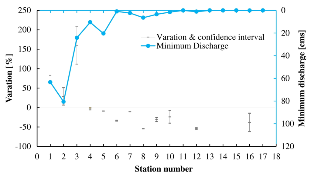
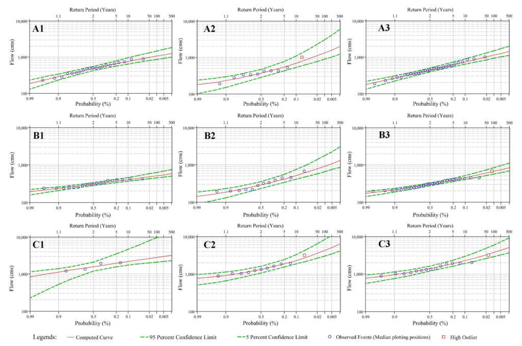
Flooding is one of the critical natural disasters in Afghanistan, causing huge social and economic losses on an annual basis. Due to lack of historical data and long gaps in the recorded data, flood predictions are usually associated with large uncertainties. The available hydrological data are collected before and after the Afghan civil war period. This long gap and climate change effects split the dataset and faces a challenge of using either dataset alone for predicting flood characteristics. In this study, first, the two datasets are compared to find river flow variation in terms of peak and frequency. Next, the river flow variation effects on flood peaks for each return period are analyzed to determine the flood projection. The results show that flood peaks have raised while the mean discharge in the basin is reduced during the second period. The frequency analyses show a change in high and low flow days in the recent period. In addition, the flood recurrence results show that the utilization of single period data for return period flood predictions yield huge variation, while the analyses using the combined dataset show a reasonable estimation of flood characteristics. Furthermore, the comparison ofcalculated flood peaks based on the first period and combined dataset show that flood peaks have an upward trend.
Download the articleHow to cite: Mayar, M. A., Asady, H., & Nelson, J. (2020). River flow analyses for flood projection in the Kabul River Basin. Central Asian Journal of Water Research, 6(1), 1–17. https://doi.org/10.29258/cajwr/2020-r1.v6-1/1-17.eng
References
- Alfieri, L., Burek, P., Feyen, L. and Forzieri, G., 2015. Global warming increases the frequency of river floods in Europe. Hydrology and Earth System Sciences. Vol. 19, pp. 2247–2260. Available at: https://doi.org/10.5194/hess-19-2247-2015.
- ASDC. Afghanistan Spatial Data Center – ASDC/IMMAP (Web, map, dashboard, infographic). Afghanistan. Available online at: http://asdc.immap.org/. (Verified on 16 June 2019).
- Bartles, M., Brunner, G., Fleming, M., Faber, B. and Slaughter, J., 2016. HEC-SSP Statistical Software Package User’s Manual, Version 2.1. ed. US Army Corps of Engineers, Hydrologic Engineering Center, Davis, CA 95616. Available at: https://www.hec.usace.army.mil/software/hec-ssp/documentation.aspx.
- Brunner, G. and Fleming, M., 2010. HEC-SSP Statistical Software Package. US Army Corps Eng. Inst. Water Resour. Hydrol. Eng. Cent. HEC. Available at: https://www.hec.usace.army.mil/software/hec-ssp/.
- CRED/EM-DAT data. Centre for Research on the Epidemiology of Disasters (CRED) – International Disaster database (EM-DAT),. Available at: https://www.emdat.be/. (Verified on 16 June 2019).
- NSIA, 2018. Afghanistan Statistical Year Book 2017 – 18. Issue 39. National Statistics and Information Authority (NISA). Kabul Afghanistan. Available at: https://www.nsia.gov.af:8080/wp-content/uploads/2019/04/Afghanistan-Statistical-Year-book-2017-18-3.pdf.
- England Jr, J., Cohn, T., Faber, B., Stedinger, J., Thomas Jr, W., Veilleux, A., Kiang, J. and Mason, R., 2015. Guidelines for determining flood flow frequency. Bull. 17C US Geol. Surv. Tech. Methods. Available at: https://acwi.gov/hydrology/Frequency/b17c/archive/bulletin17c_draft_for_public_review.pdf.
- Favre, A. and Kamal, G.M., 2004. Watershed atlas of Afghanistan. Kabul (Afghanistan). Available at: http://aizon.org/watershed_atlas.htm.
- Hagen, E., Shroder Jr, J., Lu, X. and Teufert, J.F., 2010. Reverse engineered flood hazard mapping in Afghanistan: A parsimonious flood map model for developing countries. Quaternary International, Vol. 226, pp. 82–91. Available at: https://doi.org/10.1016/j.quaint.2009.11.021.
- Hagen, E. and Teufert, J., 2009. Flooding in Afghanistan: A crisis, in: Threats to Global Water Security. Springer, pp. 179–185. Available at: https://link.springer.com/chapter/10.1007/978-90-481-2344-5_19.
- Haritashya, U.K., Bishop, M.P., Shroder, J.F., Bush, A.B.G. and Bulley, H.N.N., 2009. Space-based assessment of glacier fluctuations in the Wakhan Pamir, Afghanistan. Climatic Change, Vol. 94, pp. 5–18. Available at: https://doi.org/10.1007/s10584-009-9555-9.
- Interagency Advisory Committee on Water Data, 1982. Guidelines for determining flood flow frequency. US Geological Survey Reston, VA. Available at: https://water.usgs.gov/osw/bulletin17b/dl_flow.pdf.
- Najmuddin, O., Deng, X., Bhattacharya, R., Najmuddin, O., Deng, X. and Bhattacharya, R., 2018. The Dynamics of Land Use/Cover and the Statistical Assessment of Cropland Change Drivers in the Kabul River Basin, Afghanistan. Sustainability, Vol. 10, No. 423. Available at: https://doi.org/10.3390/su10020423.
- Omar, M.H., 2018. Drought analysis of the Kabul River Basin using hydrologic data (M.Sc. Thesis). Kabul Polytechnic University, Kabul Afghanistan.
- Sadid, N., Haun, S. and Wieprecht, S., 2017. An overview of hydro-sedimentological characteristics of intermittent rivers in Kabul region of Kabul river basin. International Journal of River Basin Management, Vol. 15, pp. 387–399. Available at: https://doi.org/10.1080/15715124.2017.1321004.
- Sarikaya, M.A., Bishop, M.P., Shroder, J.F. and Olsenholler, J.A., 2012. Space-based observations of Eastern Hindu Kush glaciers between 1976 and 2007, Afghanistan and Pakistan. Remote Sensing Letters, Vol. 3, pp. 77–84. Available at: https://doi.org/10.1080/01431161.2010.536181.
- Vick, M.J., 2014. Steps towards an Afghanistan–Pakistan water-sharing agreement. International Journal of Water Resources Development, Vol. 30, No. 2, pp. 224-229, Available at: https://doi.org/10.1080/07900627.2014.886471.
- Westfall, A., Latkovich, V., 1966. Surface water resources investigations plan for Afghanistan. USGS. Available at: http://afghandata.org:8080/jspui/bitstream/azu/3547/1/azu_acku_pamphlet_hd1698_a3_w47_1966_w.pdf.
- WFP, UNEP, NEPA, N.E.P.A., 2016. Climate change in Afghanistan: What does it mean for rural livelihoods and food security? Afghanistan. Available at: https://www.wfp.org/publications/climate-change-afghanistan-what-does-it-mean-rural-livelihoods-and-food-security.
- World Bank, 2010. Afghanistan – Scoping Strategic Options for Development of the Kabul River Basin: A Multisectoral Decision Support System Approach. World Bank, Washington, DC. Available at: http://documents.worldbank.org/curated/en/319391468185978566/Afghanistan-Scoping-strategic-options-for-development-of-the-Kabul-River-Basin-a-multisectoral-decision-support-system-approach.