Broadband albedo and area changes of the Ak-Shyjrak Glacier Massif during 1994-2018, Tien Shan, Kyrgyzstan
Zarylbek Rakhmatilla uulu1*, Ryskul Usubaliyev1, Andrey V. Mitusov2
1 Central Asian Institute of Applied Geosciences (CAIAG), Bishkek, Kyrgyzstan
2 Kazakh-German University, Almaty, Kazakhstan
*Corresponding author: zaryl_06_92@mail.ru
Ryskul Usubaliyev: r.usubaliev@caiag.kg; Andrey V. Mitusov: a_mitusov@mail.ru
https://doi.org/10.29258/CAJWR/2019-R1.v5-1/85-95.engResearch article
Abstract
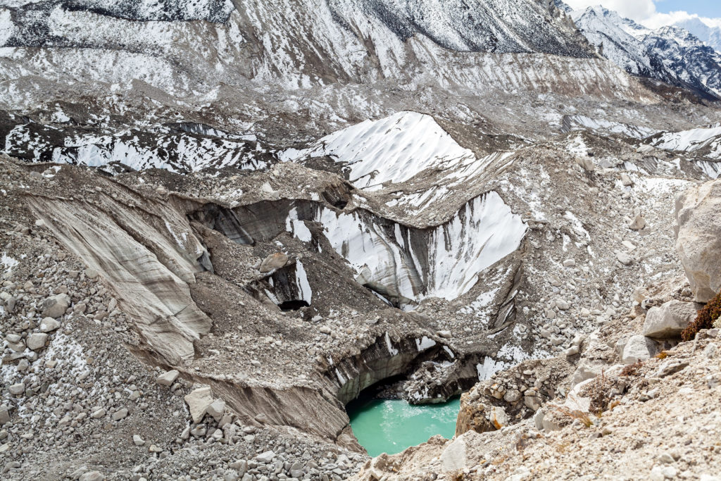
The Ak-Shyjrak Massif is considered one of the main water sources of the Naryn (a tributary of the Syr Darya) and Sary-Dzhaz (a tributary of the Aksu and Tarim) Rivers and, thus, should be subject to annual surveying to forecast the water content of these rivers. This article examines the long-term dynamics of the broadband albedo of snow and ice, as well as the area dynamics of the Lysyi, Davydov and Sary-Tor South Glaciers of the Ak-Shyjrak Glacier Massif (Kyrgyzstan). The Landsat satellite data series were used as the source data. It was established that during 1994-2018 the retreat of the glacier tongue for the Lysyi amounted to 698 m, 381 m for the Sary-Tor South and 1,926 m for the Davydov. The total loss of glacier area came up to 1.7 km2 (39.6%) for the Lysyi, and 3.6 km2 (30.3%) cumulatively for the Sary-Tor South and Davydov. Since 2005, the melting has significantly slowed down compared to the previous years. Based on the shortwave and visible band data collected in 2006, the broadband albedo at the altitudes from 3,899 to 4,200 m ASL was extremely low compared to other satellite imagery. It was noted that in the accumulation zone – the altitude from 4,200 to 4,799 m – the snow cover was permanent leading to higher albedo values. In the course of 1994-2018, the mean broadband albedo had fluctuated from 0.200 to 0.531 (summer-autumn). A satellite image of 2006 with extremely low albedo values deserved special attention. The highest albedo value was recorded in 2018. The reason underlying the sharp albedo increase was the recent snowfall over the surveyed area.
Download the articleHow to cite:
Rakhmatilla, Z., Usubaliyev, R., & Mitusov, A. V. (2019). Broadband albedo and area changes of the Ak-Shyjrak Glacier Massif during 1994-2018, Tien Shan, Kyrgyzstan. Central Asian Journal of Water Research, 5 (1), 85–95. https://doi.org/10.29258/CAJWR/2019-R1.v5-1/85-95.eng
References
- Konovalov, V.G. and Rudakov, V.A. (2015). Determine of glacier characteristics by remote sensing data. Journal of Siberian Federal University. Engineering & Technologies, 8(1), 98.
- Kutuzov, S. and Shahgedanova, M. (2009). Glacier retreat and climatic variability in the eastern Terskey-Alatoo, inner Tien Shan between the middle of the 19th century and beginning of the 21st century. Global and Planetary Change, 69(1-2), 59-70;
- Li, Z. and Leighton, H.G. (1992). Narrowband to broadband conversion with spatially autocorrelated reflectance measurements. Journal of Applied Meteorology and Climatology, 31(5), 421-432.
- Liang, S. (2000). Narrowband to broadband conversions of land surface albedo I: Algorithms. Remote sensing of environment, 76(2), 213-238.
- Liang, S., Strahler, A.H., Walthall, C. (1999). Retrieval of land surface albedo from satellite observations: A simulation study. Journal of Applied meteorology, 38(6), 712-725;
- Petrakov, D., Shpuntova, A., Aleinikov, A., Kääb, A., Kutuzov, S., Lavrentiev, I., Stoffel, M., Tutubalina, O. and Usubaliev, R. (2016). Accelerated glacier shrinkage in the Ak-Shyirak massif, Inner Tien Shan, during 2003-2013. Science of the Total Environment, 562, 364-378.
- Petrakov, D.A., Shpuntova, A.M., Aleinikov, A.A., Usubaliyev, R.A. (2014). Izmenenija oledenenija massiva Ak-Shyzhrak (Vnutrennij Tjan’-Shan’) v 2003-2013 gg. [Changes in the glaciation of the Ak-Shyjrak Massif (Inner Tien Shan) in 2003-2013] // Materials of the International Conference “Remote and Ground Earth Research in Central Asia”, Bishkek, 2014, pp. 352-358 [In Russian].
- Singh, D.K., Gusain, H.S., Mishra, V.D. and Gupta, N. (2019). Automated retrieval of snow/ice surface broadband albedo in Beas River Basin, India using landsat-8 satellite images and validation with wireless sensor network data. Journal of the Indian Society of Remote Sensing, 47(1), 33-44.
- U.S. Geological Survey (n.d.). Landsat Missions, Landsat 8. Retrieved December 18, 2018 from https://www.usgs.gov/core-science-systems/nli/landsat/landsat-8?qt-science_support_page_related_con=0#qt-science_support_page_related_con).
- Valiente, J.A., Nunez, M., Lopez-Baeza, E. and Moreno, J.F. (1995). Narrow-band to broad-band conversion for Meteosat-visible channel and broad-band albedo using both AVHRR-1 and-2 channels. Remote Sensing, 16(6), 1147-1166.
glacier ablation, glacier albedo, glacier area, glacier degradation