Evaluation of hydrological processes (floods, high water, lateral erosion and mudflows) in the Kara-Unkyur River Basin (Kyrgyzstan)
Moldobekov B. D.
Central-Asian Institute for Applied Geosciences (CAIAG), Kyrgyzstan (b.moldobekov@caiag.kg)
Abdibachaev U. A.
Central-Asian Institute for Applied Geosciences (CAIAG) ), Kyrgyzstan
Kalashnikova O. Ju.
Central-Asian Institute for Applied Geosciences (CAIAG) ), Kyrgyzstan
Scientific Article
Abstract
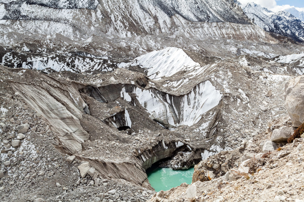
Almost in all river basins of Central Asia, with the onset of spring, the probability of natural disasters, such as floods, high water and related lateral erosion, increases. Especially, these phenomena often occur in large river basins of Fergana Valley, Kyrgyz ridge and Trans-Ili Alatau. The aim of this study was to identify vulnerable areas affected by erosion processes in the course of disastrous floods and high water in order to take preventive measures for protection of settlements, their territories and infrastructure. To identify vulnerable areas affected by erosion processes in the Kara-Unkyur River Basin, a complex of field methods of ground-based observation was implemented with the use of Remote Sensing (RS) data. Based on the obtained data, a degree of manifestation of exogenous geological processes was analyzed and evaluated. Recommendations for decision-making were elaborated and submitted to the state authorities (Ministry of Emergency Situations of the Kyrgyz Republic, MES).
Download the articleHow to cite: Moldobekov, B. D., Abdibachaev U. A., Kalashnikova O. Ju.(2017). Evaluation of hydrological processes ( floods , high water , lateral erosion and mudflows ) in the Kara-Unkyur River Basin ( Kyrgyzstan ). Central Asian Journal of Water Research (CAJWR) 3(1), 43–53.
References
- Atlas of the Kyrgyz SSR, published by GUGK, 1987.-Т.I.-157 p., (in Russian).
- Isaev D. I., Glushkov M. I., Aliev Z. A., Danilina A. P., Tokombaev Sh. Landscape of Kyrgyzstan, published by Frunze Ilim, 1964.-154 p., (in Russian).
- Mamatkanov D. M., Bajanova L. B., Romanovskii B. B. Water Resources of mountainous Kyrgyzstan at the present stage, published by Bishkek Ilim, 2006-276 p., (in Russian).
- Climate of the Kyrgyz SSR, Rjazanzeva Z. A. (ed.), published by Frunze Ilim, 1965.- 291 p., (in Russian).
- Criteria of hazardous hydrometeorological events and the procedure for filing a storm note about their occurrence. Procedure document. Main Department of Hydrometeorology of the Ministry of Emergency of the Kyrgyz Republic. Bishkek, 2002, pp.4-5, (in Russian).
- Lomatdze V. D. Engineering geology. Special engineering geology, Subsoil, 1978. – 496 p. UDK 624.131.1, (in Russian).
- Bondarik G. K. Methodic of engineering-geological studies. Subsoil, 1986.-333 p., (in Russian).
- Perov V. F. Mudflow studies, published by the Geographical faculty of Moscow State University, 2012-272 p., (in Russian).
- Abdibachaev U., Moldobekov B. D., Ibatulin H. V. New cadastration of landslide risks based on the example of the Alay district of the Osh region of Kyrgyzstan. // Remote and field studies in Central Asia: materials of international conference, 2014, 193-197 p. ISBN 978-9967-11-449-4, (in Russian).
- Ormukov Ch. A., Abdibachaev U. A., Moldobekov B. D. Inventory and evaluation of mudflow risks in the region of the city Sjuljukta of the Bartken region of Kyrgyzstan. // Remote and field studies in Central Asia: materials of international conference, 2014, 193-197 p. ISBN 978-9967-11-449-4, (in Russian).
- Nijazov R. A., Minchenko V. D., Tashmatov H. M. Monitoring of exogenous geological processes, published by Tashkent “Fun”, 1991. 180 p., (in Russian).
- Roessner S. Behling R., Abdybachaev U. Multi-temporal optical and radar satellite remote sensing for spatial-temporal analysis of landslide activity at a regional scale in southern Kyrgyzstan. // Remote and field studies in Central Asia: materials of international conference, 2014, 80-85 p. ISBN 978-9967-11-449-4.
- Podobnikar Tomaz, Methods for visual quality assessment of a digital terrain model. S.A.P.I.E.N.S. 2.2 /2009:VOL.2/No.2 Special Issue.
- A series of issues “GEOMATIC” from 2008 to 2015. http://geomatica.ru/eng/archive.html (in Russian).
- Kopackova V., Rapprich V., and etc. Slope dependent morphometric analysis as a tool contributing to reconstruction of volcano evolution. Earth and Environmental Sciences. 219-240 p. 2011. http://cdn.intechopen.com/pdfs/24557.pdf.
- Monitoring, forecasting of dangerous processes and phenomena on the territory of the Kyrgyz Republic. MES KR. 2013 and 2014, ISBN 978-9967-23-948-4, (in Russian).
- Guidance on hydrometeorological forecasts, issue 1, Gidrometeoizdat, 1989, (in Russian).
- Karamoldoev J. J., Kalashnikova O. Ju. . Evaluation of correlation links of the vegetation runoff of the rivers of Upper Naryn. The materials of the international conference, KRSU 20 years. 2013, (in Russian).
- Kalashnikova O. Development of long-term forecast methods for the flow of mountain rivers and the inflow of water into the reservoir using the example of the Naryn River, published by Science and new technologies and innovations of Kyrgyzstan. Bishkek No. 5, 2015, (in Russian).
- A. Gafurov, S. Ludtke, K. Unger-Shayesteh, S. Vorogushyn, T. Scho¨ne, S. Schmidt, O. Kalashnikova, B. Merz. MODSNOW-Tool: an operational tool for daily snow cover monitoring using MODIS data. Environ Earth Science (2016) 75:1078.
- Draft guidelines for the forecast of mudflow hazard in the foothills of the Fergana Valley. Proceedings of SANII, Goskomgidromet, 1984. p.13., (in Russian).
- Salihova D. H. Aerosynoptic method of short-term forecast of snow-rain floods in the Kashkadarya river. Theoretical and applied meteorology, published by “Fun” Uzb SSR,1975, volume 2, (in Russian).
- Salihova D. H., Ljahovskaja L. F. Forecast of mudflow hazard in the Surkhandaria River Basin, works of SINII, Kyrgyzhydromet, 1982, volume.89(170), pp.121-125, (in Russian).
- http://landsat.usgs.gov/Landsat_7_ETM_SLC_off_data_products.php «estimated 22 % of any given scene is lost because of the SLC-off failure».
catastrophic floods, erosion processes, hydrological processes, kara-unkur river, remote sensing